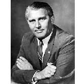
ScienceIQ.com

When and Why is Blood Typing Done?

Fans of the popular television show ER know how important blood type is in an emergency. 'Start the O-neg,' shouts Doctor Green, and the team swings into action. Green calls for type O, Rh-negative blood in life-and-death situations when there's no time for blood typing. Since that type contains no A, B, or Rh antigens, it can - in theory - be ...

Continue reading...

BloodTypes
Engineering

Barn Yard Aeronauts

The word aeronaut is derived from the Greek terms 'aero' meaning air or atmosphere and 'nautes' meaning sailor. Originally, individuals who piloted balloons or airships (blimps or dirigibles) were ... Continue reading

BarnYardAeronauts
Biology

Is Catnip a Drug for Cats?

Most people think of catnip as having drug-like effects on their cats. Some cats lick it, eat it or just sniff it and owners can see a definite behavior change. Catnip is actually a plant from the ... Continue reading

IsCatnipaDrugforCats
Geology

Finding Ice In The Rocks--Evidence Of Earth's Ice Ages

In the late 1700s, geologists began trying to determine how huge boulders of granite weighing several tons could have moved as much as 80 km (50 miles) from their origins in the Swiss Alps. Some ... Continue reading

EarthsIceAges
Engineering

Bioinformatics

Bioinformatics is the field of science in which biology, computer science, and information technology merge to form a single discipline. The ultimate goal of the field is to enable the discovery of ... Continue reading

Bioinformatics

What is Geodesy?

WhatisGeodesyGeodesy is the science of measuring and monitoring the size and shape of the Earth. Geodesists basically assign addresses to points all over the Earth. If you were to stick pins in a model of the Earth and then give each of those pins an address, then you would be doing what a geodesist does. By looking at the height, angles, and distances between these locations, geodesists create a spatial reference system that everyone can use. Building roads and bridges, conducting land surveys, and making maps are some of the important activities that depend on a spatial reference system. For example, if you build a bridge, you need to know where to start on both sides of the river. If you don't, your bridge may not meet in the middle. As positioning and navigation have become fundamental to the functions of society, geodesy has become increasingly important.

Geodesy helps the transportation industry ensure safety and reliability, while reducing costs. Without geodesy, planes might land next to -- rather than at -- airports, and ships could crash onto land. Geodesy also helps shipping companies save time and money by shortening their ships' and airplanes' routes and reducing fuel consumption. Geologists, oceanographers, meteorologists, and even paleontologists use geodesy to understand physical processes on, above, and within the Earth. Because geodesy makes extremely accurate measurements (to the centimeter level), scientists can use its results to determine exactly how much the Earth's surface has changed over very short and very long periods of time.

The Earth's surface changes for many reasons. For instance, its surface rises and falls about 30 centimeters (about 1 foot) every day due to the gravitational influences of the moon and the sun. The Earth's outermost layer, the crust, is made up of a dozen or more