


The Hole Scoop on Ozone
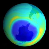 Ozone is a molecule containing three oxygen atoms. It is blue in color and has a strong odor. Normal oxygen, which we breathe, has two oxygen atoms and is colorless and odorless. Ozone is much less common than normal oxygen. Out of each 10 million air molecules, about 2 million are normal oxygen, but only 3 are ozone. However, even the small amount of ozone plays a key role in the atmosphere. The ozone layer absorbs a portion of the radiation from the sun, preventing it from reaching the planet's surface. Most importantly, it absorbs the portion of ultraviolet light called UVB. UVB has been linked to many harmful effects, including various types of skin cancer, cataracts, and harm to some crops, certain materials, and some forms of marine life.
At any given time, ozone molecules are constantly formed and destroyed in the stratosphere. The total amount, however, remains relatively stable. The concentration of the ozone layer can be thought of as a stream's depth at a particular location. Although water is constantly flowing in and out, the depth remains constant. While ozone concentrations vary naturally with sunspots, the seasons, and latitude, these processes are well understood and predictable. Scientists have established records spanning several decades that detail normal ozone levels during these natural cycles. Each natural reduction in ozone levels has been followed by a recovery. Recently, however, convincing scientific evidence has shown that the ozone shield is being depleted well beyond changes due to natural processes.